Wheeldale Roman Road

Wheeldale Roman Road, Wheeldale Road, Goathland, North Yorkshire YO22 5AP, UK
1-99 Years

Description

Wheeldale Roman Road is an enigmatic mile-long stretch of ancient road amid wild and beautiful moorland. The road is probably Roman but possibly later or earlier, and still has its hard core and drainage ditches. The linear monument on Wheeldale Moor is first recorded as ‘Wade’s Causeway – a Roman Way’ on a map of 1720. 

It then features in most antiquarian accounts of the area as part of a Roman road, traced for various distances along a route from Amotherby, near Malton, in the south towards the coast north of Whitby, a distance of some 33 to 35 miles. More recent work, however, has suggested that it could be medieval, or that it might not be a road at all, but a much modified Neolithic or early Bronze Age boundary feature. 

Free Entry. If you are looking for Best place for day out with kids and families then this is the perfect destination offering fun, adventure, and unforgettable memories for everyone.

Features

  • Free
  • Host birthday parties: No

Features

  • History of Wheeldale Roman Road: The linear monument on Wheeldale Moor is first recorded as ‘Wade’s Causeway – a Roman Way’ on a map of 1720. It then features in most antiquarian accounts of the area as part of a Roman road, traced for various distances along a route from Amotherby, near Malton, in the south towards the coast north of Whitby, a distance of some 33 to 35 miles. More recent work, however, has suggested that it could be medieval, or that it might not be a road at all, but a much modified Neolithic or early Bronze Age boundary feature.
  • The visible section of ‘road’ has been in state guardianship since 1912. As it is now seen, it was uncovered between 1912 and 1920, following initial clearance of some areas in the 1890s.
  • The name Wade’s Causeway, as the site is also known, derives from a local legend that the ‘road’ linked the home of a giant called Wade who lived at Mulgrave Castle with that of his wife, Bel, who lived at Pickering Castle.
  • A Roman Road? The most comprehensive published study of the site as a Roman road[3] traces the southern part of the suggested route in a series of alignments, largely through plotting findspots of Roman material in association with the topography within what would have been the extensive wetlands of the Vale of Pickering. Not surprisingly, Roman and other finds are recorded on islands of higher ground. Similarly, to the north of the visible section Roman finds have been plotted to create a possible route to the southern edge of the Esk valley.
  • Possible Southern Route: Controversy surrounds the suggested route of the road near Cawthorn Camps. A long-held view[7] is that it traversed the part of the Cawthorn complex know as ‘Camp’ D (in fact a Roman fort) and then descended from the escarpment on which the Roman earthworks sit to the valley of the Sutherland Beck. An alternative line would have the road descending the scarp about half a mile to the west, on the line of the modern access to Sutherland Lodge.
  • Possible Northern Route: To the north, the course of the visible stretch of the monument points towards the Roman fort at Lease Rigg, although the line traditionally suggested for the route of the road there cuts obliquely south-west to north-east across the fort.
  • Other Possible Origins: It is quite possible that the road, if that is what it was, is medieval in date or at least was used in the medieval period. The religious houses of the region are known to have exploited the mineral resources of the North York Moors and the road may have been designed to provide access to them.[15] There is little evidence, however, to support this proposal.

Facilities

Parking: It is possible to park on the roadside, but please take care.

Price

Price: Free

Birthday Parties

Offer Birthday Parties: No

Open any reasonable time during daylight hours.

Address: Wheeldale Roman Road, Wheeldale Road, Goathland, North Yorkshire YO22 5AP, UK

Post Code: YO22 5AP

Council: North Yorkshire

County: North Yorkshire

  • Road Access: South of Goathland; West of A169; 7 miles South of Whitby.
  • Bus Access: Yorkshire Coastliner service 840 to Goathland then 4 miles walk. Alternatively alight at Ellerbeck bridge and walk 2 1⁄2 miles over Howl Moor.
  • Train Access: Goathland (
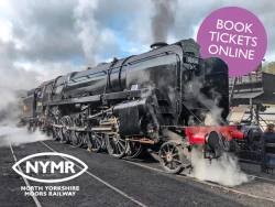
North Yorkshire Moors Railway) (4 miles) or Newtondale Halt (then 3 mile forest walk)
  • Bicycle Access: Find this site on The National Cycle Network.
  • Parking: It is possible to park on the roadside, but please take care.

0.00

0 Reviews

Rating breakdown

5
80% Complete (danger)
0
4
80% Complete (danger)
0
3
80% Complete (danger)
0
2
80% Complete (danger)
0
1
80% Complete (danger)
0

More Day Outs in North Yorkshire

Get the best blog stories into your inbox!